
National Oceanic and Atmospheric Administration (NOAA) is the United States’ main source for environmental intelligence and weather prediction. Within NOAA's operations is a comprehensive aircraft fleet utilizing cutting-edge technology to support a range of missions, from climate monitoring to storm tracking.
As experts in aerospace solutions, our team at Greenwood Aerospace appreciates the complexity and importance of the technology aboard these aircraft. With decades of experience in aircraft and parts procurement, we understand the intricate layers of design and function that comprise NOAA's high-tech fleet.
This article delves into the fascinating technology aboard NOAA's aircraft, and the need for diligent aircraft sustainment to ensure they have the most cutting-edge weather monitoring technology up-to-date and functioning properly. We'll also touch on NOAA's 2022 Aircraft Plan for aircraft sustainment, a comprehensive strategy ensuring these mission-critical vehicles' efficiency and longevity.
NOAA’s Aircraft: Weather & Climate Watchers
In NOAA's diverse fleet, each aircraft is kitted for a specific purpose, all serving the overarching mission of enhancing our understanding of the environment. For the purposes of this article, we’ll focus on the fixed-wing aircraft in the fleet, looking at their unique features, functions, and roles within the agency, including:
- Beechcraft King Air 350
- De Havilland DHC-6 Twin Otter
- Lockheed WP-3D Orion
- Gulfstream IV-SP
Through this, we hope to provide a comprehensive understanding of the diverse technological facets and the crucial mission applications these airplanes support. Whether remote sensing, storm tracking, or data gathering, these aircraft represent the tangible, airborne aspect of NOAA's dedication to environmental intelligence.
Beechcraft King Air 350
Also used by Customs and Border Protection, the Beechcraft King Air 350 is a reliable and high-performing twin-turboprop aircraft that has become integral to NOAA's airborne operations since its induction. Famed for its robustness, extended range, and payload capabilities, this aircraft offers a solid platform for various mission equipment and scientific devices, making it a preferred choice for many of NOAA's key tasks.
Responsibilities of the Beechcraft King Air 350 include:
- Coastal mapping
- Emergency response
- GRAV-D
- Monitoring ice seals
One of the key functions of the Beechcraft King Air 350 is coastal mapping. Equipped with advanced Light Detection and Ranging (LiDAR) systems and high-resolution cameras, it provides highly accurate and detailed coastal and oceanic surveys, thereby aiding in monitoring coastal erosion, flood risk assessments, and storm impact analysis.
The King Air 350 also serves a critical role in emergency response. With its short takeoff and landing capabilities, it can reach areas that are otherwise inaccessible, delivering supplies and aiding in evacuation during natural disasters. Its ability to gather real-time data aids in strategizing and implementing relief operations.
Another specialized mission of this aircraft is the Gravity for the Redefinition of the American Vertical Datum (GRAV-D) project. The GRAV-D mission aims to redefine the U.S.'s vertical datum, the measurement of the Earth’s heights and depths, by 2022. With its advanced gravity measurement tools, the Beechcraft King Air 350 contributes significantly to this project by collecting airborne gravity data.
Finally, the aircraft is also used for monitoring ice seals in the Arctic regions. Using its high-resolution imaging systems, the King Air 350 tracks and monitors the population and health of these vital indicators of Arctic ecosystem health.
De Havilland DHC-6 Twin Otter
The De Havilland DHC-6 Twin Otter is another key member of the NOAA fleet, prized for its exceptional performance in harsh conditions and its unique versatility. Introduced to supplement and enhance the agency's range of capabilities, the Twin Otter has proven its worth across a wide array of mission profiles, including:
- Snow surveying
- FIREX air chemistry measurements
- Arctic heat monitoring
- Coastal mapping
- Post-disaster mapping
- Marine animal tracking
A standout mission of the Twin Otter is snow surveying. Given the aircraft's ability to operate in extreme cold and harsh conditions, it's ideally suited to traverse and monitor regions of heavy snowfall. These surveys provide valuable data for predicting water supply and flood potential and are crucial for understanding the impacts of climate change on our planet's cryosphere.
Under the Fire Influence on Regional to Global Environments and Air Quality (FIREX-AQ) program, the Twin Otter is also deployed for air chemistry missions. Equipped with advanced sensors and collection equipment, it gathers data on smoke emissions from wildfires and agricultural fires. This information helps scientists understand the impact of such fires on air quality and climate.
As part of NOAA’s Arctic Heat Open Science Experiment, the Twin Otter contributes significantly to gathering data on the rapidly changing Arctic environment. The aircraft drops radiosondes and deploys airborne expendable bathythermographs to capture vertical profiles of atmospheric and oceanic conditions, providing critical insights into Arctic warming trends.
Lastly, the Twin Otter's role in marine animal tracking cannot be overlooked. Its ability to fly at low altitudes and slow speeds and its adaptability to various equipment configurations allows it to track and monitor marine animals effectively. This helps scientists understand migration patterns, population trends, and the impacts of climate change on marine ecosystems.
Lockheed WP-3D Orion Tour
The Lockheed WP-3D Orion, often recognized as one of the most sophisticated meteorological data collection platforms worldwide, is an iconic part of the NOAA fleet. Introduced with the specific purpose of intensifying NOAA's atmospheric and storm research capabilities, the WP-3D Orion plays a significant role in advancing our understanding of severe weather phenomena by conducting:
- Hurricane reconnaissance and research
- Study of atmospheric rivers
- Ocean winds measurements
- Tornado studies
- Air chemistry missions
- Long endurance GRAV-D
- Coastal mapping
Known as the “hurricane hunters”, these planes are customized for weather exploration tasks. The WP-3D Orion is built to fly into storms and hurricanes bravely. It collects up-to-the-minute information about the storm's power, internal structure, and behavior. This invaluable information is then used to improve the accuracy of weather forecasting models, helping us predict the path and strength of hurricanes.
The WP-3D Orion doesn't just stop at storms. It's also designed to study what are called “atmospheric rivers”. These are slender areas in the sky that carry most of the moisture outside tropical regions. By monitoring these using its high-tech instruments, the Orion provides insights that help us understand weather patterns and the possibility of flood events.
The WP-3D Orion is also key in the Ocean Winds mission and monitoring tornadoes. Using its advanced sensors, it can measure the speed of winds. This information improves weather predictions and climate models.
Gulfstream IV-SP
Another member of the “hurricane hunters” fleet is the Gulfstream IV-SP.
The Gulfstream IV-SP (G-IV) is a high-speed, high-altitude jet in NOAA's airborne operations. Introduced to augment the agency's upper-atmospheric research and storm forecasting capabilities, the G-IV has added a valuable strategic layer to NOAA's meteorological missions.
What sets the G-IV apart is its exceptional flight performance. Capable of reaching altitudes of up to 45,000 feet and speeds close to Mach 0.9, the G-IV provides NOAA with a platform for high-altitude and long-distance research missions. This high operational ceiling and speed make it particularly useful for missions requiring large geographical area coverage or rapid deployment to distant locations.
NOAA uses the G-IV for:
- Hurricane surveillance and research
- Monitoring atmospheric rivers
- GRAV-D operations
The aircraft is typically deployed to gather data from the upper atmosphere surrounding these storms, which is critical for understanding their potential development and movement. Its impressive range allows it to perform these missions over both the Atlantic and Pacific Oceans.
The introduction of the Gulfstream IV-SP into NOAA's fleet has substantially improved the agency's ability to perform high-altitude, long-range meteorological research and storm prediction. The aircraft's advanced capabilities underline the importance of maintaining and sustaining such a high-performing asset in support of NOAA's crucial mission objectives.

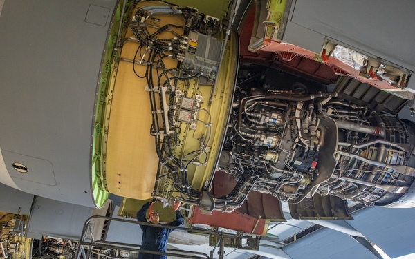
Technological Marvels Onboard NOAA Aircraft
While these aircraft have incredible capabilities, the onboard technology makes them crucial to NOAA operations. The fascinating part, however, is their advanced technical equipment and the integrated systems that ensure these assets are available, ready, and performing optimally for each mission. This is where aircraft sustainment is a critical part of the overall technological framework onboard.
In this section, we’ll take a look at:
- Dropsondes: Devices released from aircraft during weather reconnaissance missions
- Advanced Vertical Atmospheric Profiling Systems (AVAPS): Data collector and transmitter for dropsondes
- Airborne Expendable Bathythermograph (AXBT): Used for measuring ocean temperatures
- Tail Doppler Radar & Low Fuselage Radar: Gather critical data on rainfall rates, wind speeds, storm intensity, and more
Dropsondes
Dropsondes are indispensable tools used by NOAA for capturing high-resolution vertical profiles of the atmosphere.
They’re small, expendable, instrument-filled tubes dropped from an aircraft to measure various atmospheric parameters. This game-changing weather technology has greatly advanced our understanding of the atmosphere, contributing to more accurate weather predictions. But what makes dropsondes so special? Let's delve into the science behind them.
A typical dropsonde is about 16 inches long and weighs just under a pound. Despite its size, it's packed with an array of instruments that can measure temperature, humidity, barometric pressure, and wind speed and direction. These devices communicate their readings in real-time to a computer onboard the aircraft, providing a snapshot of the atmospheric conditions below.
Once the dropsonde is released from the aircraft, usually through a chute in the aircraft's belly, it begins its descent towards the Earth, slowed by a small parachute. During this descent, which lasts about 20 minutes, the dropsonde collects data from various levels of the atmosphere, transmitting this information back to the aircraft. This vertical profile of the atmosphere is invaluable for meteorologists, as it offers insights into the structure and behavior of storms and other weather systems.
Advanced Vertical Atmospheric Profiling System (AVAPS)
The Advanced Vertical Atmospheric Profiling System (AVAPS) represents a significant leap forward in atmospheric data collection for NOAA. This system is designed to gather high-resolution, real-time vertical profiles of the atmosphere, significantly enhancing NOAA's ability to monitor and predict weather patterns.
At the heart of AVAPS is the dropsonde - the device we previously discussed. The dropsonde is released from the aircraft and, as it descends towards the Earth, it collects and transmits data on various atmospheric parameters. But the real magic of AVAPS lies in its ability to process and analyze this data in real-time.
Once the data is transmitted back to the aircraft, AVAPS interprets it on the fly, creating an immediate and detailed snapshot of atmospheric conditions. This real-time interpretation allows for instant adjustments to the mission plan if needed, and the data can be shared quickly with meteorological centers for immediate incorporation into weather and climate models.
AVAPS is used on several NOAA aircraft, including the high-altitude Gulfstream IV-SP, where it plays a crucial role in hurricane forecasting. By gathering detailed data on the upper atmosphere surrounding tropical cyclones, AVAPS contributes significantly to understanding these storms' potential development and path.
Airborne Expendable Bathythermograph (AXBT)
The Airborne Expendable Bathythermograph (AXBT) is a vital instrument in NOAA's technology arsenal. Dropped from aircraft into the ocean, AXBTs measure temperature profiles down to about 1000 meters. This data is essential in understanding weather and climate patterns, including the development and intensity of tropical cyclones, and tracking changes in ocean currents.
AXBTs are deployed from various NOAA aircraft, such as the Lockheed WP-3D Orion and the Gulfstream IV-SP, contributing to their hurricane research and oceanographic missions. Thus, AXBTs play a crucial role in enhancing NOAA's capabilities in weather prediction and climate study.
Tail Doppler Radar & Low Fuselage Radar
Tail Doppler Radar (TDR) and Low Frequency Radar (LFR) are two crucial technologies installed on NOAA aircraft to enhance their meteorological missions.
As the name suggests, the Tail Doppler Radar is a radar unit installed in the tail of the aircraft. It is designed to measure the velocity of precipitation particles, offering a detailed 3-D snapshot of storm intensity, structure, and dynamics. TDR significantly enhances NOAA's ability to study storm evolution, track storm movements, and predict their future paths and intensities by providing high-resolution data on wind fields within storms.
On the other hand, the Low Fuselage Radar is a weather radar installed on the lower part of the aircraft's fuselage. It provides a horizontal view of the weather system being studied. LFR helps identify precipitation and other atmospheric disturbances and is crucial for navigating the aircraft safely through intense weather systems. This radar is particularly helpful during low-level flights in severe weather conditions when visibility can be significantly reduced.
NOAA's Lockheed WP-3D Orion aircraft are equipped with both TDR and LFR. These technologies enable NOAA scientists to collect vital data during hurricane research missions, contributing significantly to our understanding of these powerful storms and improving the accuracy of weather forecasts.
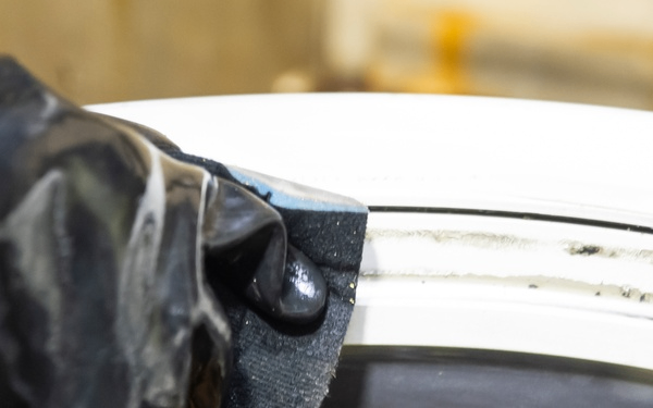
Sustaining NOAA’s Weather Aircraft Fleet
As technology advances, so do our efforts to study and understand the environment. This progress has underscored the necessity of aircraft sustainment for NOAA's fleet. But what does aircraft sustainment entail?
Simply put, aircraft sustainment is a commitment to keep our airborne platforms equipped with the latest in weather research technology, staying up-to-date and effective in an ever-evolving field.
Working with private aerospace solutions companies like Greenwood Aerospace is key in this endeavor. Their technical expertise and experience help ensure NOAA aircraft are always mission-ready, enabling NOAA to focus on its core mission of deciphering the complex world of climate, weather, oceans, and coasts
So how does NOAA make it all happen? They recently published a new implementation plan for the sustainment of NOAA aircraft. Let’s take a quick look at the plan to better understand where the fleet goes from here.
NOAA’s 2022 Implementation Plan
The comprehensive blueprint, "Update, Status, and Implementation of the NOAA Aircraft Plan, Building and Sustaining NOAA's 21st Century Fleet", outlines NOAA's future strategy. This strategy delves deep into how NOAA intends to acquire and equip new aircraft in the future. The primary goal? To ensure continuous delivery of essential data that we rely on to safeguard individuals and protect properties.
The updated NOAA Aircraft Plan aims to extend and improve the capabilities of NOAA’s Aircraft Fleet by taking into account new funding information, ongoing purchases, and best practices for fleet management. The plan addresses challenges such as increased user demands, aging and obsolete aircraft, and limited resources for fleet renewal. The goal is to ensure NOAA meets growing airborne requirements through cost-effective means, including procuring additional aircraft, updating management practices, and optimizing data collection capabilities.
Let’s take a look at the highlights:
- The plan proposes to replace two current WP-3D aircraft, one decommissioned WP-3D aircraft, and to acquire one additional aircraft with four new C-130 aircraft to meet growing airborne data requirements.
- It includes plans for the acquisition and deployment of a King Air and a second G-IV, both funded in 2022, along with an additional Twin Otter aircraft.
- The role of NOAA aircraft in storm genesis is highlighted as critical for timely decision-making to protect life and property, with WP-3D aircraft data being instrumental in improving forecasting models.
- NOAA aims to hire, train, and qualify additional personnel to ensure proper support for mission expansion.
- The plan recognizes the need for continuous technological development, the employment of a systematic approach across NOAA to leverage uncrewed systems, and strategic partnerships with other agencies.
This updated strategy, based on recent analysis and future objectives, is designed to meet NOAA’s mission requirements and to support public, national, and economic security.
Greenwood Aerospace: Reliable Procurement for Government Agencies
Sustaining the peak operational readiness of these sophisticated aircraft demands a constant flow of up-to-date parts and accessories, and this is where companies like Greenwood Aerospace become integral. Our contribution goes beyond supplying aircraft components – we help you accomplish your work quickly, safely, efficiently and in the most economical way possible. Leveraging our exclusive GPIQ Part Procurement Intelligence software, we efficiently utilize government contract budgets and minimize operational interruptions.
As a reliable provider of quality aircraft parts and other aviation services for government institutions, our portfolio includes collaborations with entities such as the U.S. Forest Service, the Department of Energy, NASA, and NOAA. We offer an inclusive suite of solutions that encompass short-term aircraft leasing, procurement of aircraft parts, and ground support, tailored to meet the distinct requirements and challenges faced by these agencies.
If you want to learn more, contact us or request a quote today!
Planning to scale up your enterprise? Collaborate with a trusted name in the aerospace sector. Discover more about how you can join us as a supplier.
Was this helpful? You might also be interested in these News stories:
.svg)


